


Necuday-La Tuile

Bogapuki
User
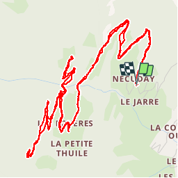

Length
10.9 km

Max alt
1343 m

Uphill gradient
482 m
Km-Effort
17.3 km

Min alt
913 m

Downhill gradient
481 m
Boucle
Yes
Creation date :
2018-11-25 09:19:12.309
Updated on :
2018-11-25 09:19:12.309
3h44
Difficulty : Easy

FREE GPS app for hiking
 SityTrail
IGN / Geographical institutes
SityTrail Plus
The world is yours!
About
Trail Walking of 10.9 km to be discovered at Auvergne-Rhône-Alpes, Savoy, La Léchère. This trail is proposed by Bogapuki.
Description
Rando printanière sans difficulté particulière
Photos

Positioning
Country:
France
Region :
Auvergne-Rhône-Alpes
Department/Province :
Savoy
Municipality :
La Léchère
Location:
Pussy
Start:(Dec)
Start:(UTM)
300885 ; 5047940 (32T) N.
Comments